

On January29, 2026, the United States Census Bureau published the Puerto Rico CommunitySurvey (PRCS) new estimates, the data refer to the five-year period 2020-2024. Unlike the estimates of one year of information by the Survey, an important aspect of publishing the five-year periods of the survey is that estimates canbe produced for all municipalities in Puerto Rico, or areas with populations below 60,000 people.
Among the variety of topics collected in the PRCS, we address the median household incomeas ad the first (1/4) of four socioeconomic aspects. A comparison was made with theprevious period 2015-2019, which allows us to examine the variations by municipios and their distribution within the jurisdiction of Puerto Rico according to the socioeconomic characteristic.
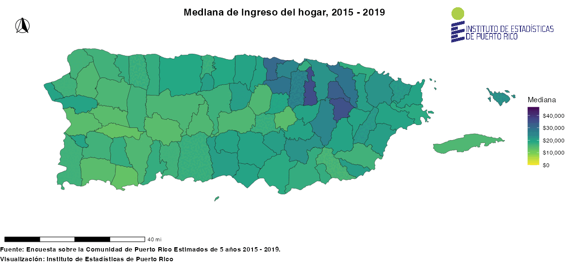
Median Household Income by Municipalities
The measure shows the amount of income that came into the household, thus householdersand all other individuals aged 15 years or older in the household.
In the period 2015-2019, the level of income between municipalities ranged from $12 thousand to $36 thousand dollars per year, with Maricao and Guaynabo being the extreme points of the distribution, respectively. During the period 2020-2024, revenues ranged from $16,000 to $47,000 annually, with Las Marías being the onewith the lowest income and Guaynabo the one with the highest income. Regarding the change within the periods considered, it should be noted that only the municipio of Maunabo did not increase its median household income.
Among the 77 municipalities that showed an increase in household income, they can besummarized as:
- 55% (42) of the municipalities increased from five thousand ($5,203) to nine thousand ($9,700) dollars
- 40% (31) of the municipalities increased from one thousand ($1,223) to four thousand ($4,988) dollars
- 5% or (4) of the municipalities increased slightly more than ten thousand ($10,258 - $10,803) dollars.
Explore more details in the table with the comparison of household income between themost recent year periods, as well as the maps with the geographicaldistribution on the Institute Census Data andInformation (SDC-PR) page.
-p-130x130q80.png)
.png)
.png)
.png)
.png)
.png)
.png)
.png)
.png)
.png)
.png)
.png)

.png)
.png)
.png)
.png)